2026.05.17 - Launch Considerations
There are two ways to launch and recover a boat from the Goldhanger Sailing Club and for the first launch at the club I don't want to do either of them. This is mainly due to not knowing how to use the club facilities. So, Plan A will be to launch from the public hard at West Mersea. The weather window looks good for Thursday the 21st May with high tides at 04:00 at Mersea and 16:50 at Osea Island. This means a Wednesday afternoon or late night drive to rig Naiad, put her in the water in the water and get out of the Mersea channels well before low water at 10:00. This would then allow a trip up the Blackwater on the rising tide.
The fly in the ointment is the predicted wind direction. The forecast has this as just South of West force 4 gusting 6 on Wednesday afternoon and early evening, moderating overnight to 3 gusting 4. This make the Public Hard at West Mersea a lee shore and those are always difficult to sail from in the best of conditions.
So, Plan A was scrapped and Plan B created.

This is one of the two public hards at Tollesbury at low water. In the forecast wind direction this is a weather shore. That it the wind blows off the land and on to the sea. The opposite of the lee shore at West Mersea. Perfect.

This is a closer look and the only obstruction is the sill at the entrance of the marina and that is where the green marker stands in the mud. The sill is concrete and not something you want to hit. Still, the launch will be at high water so there should be little chance of touching it.

This is the way out, the Woodrolfe Creek and the forecast wind will be blowing along this creek and will blow Naiad along nicely.
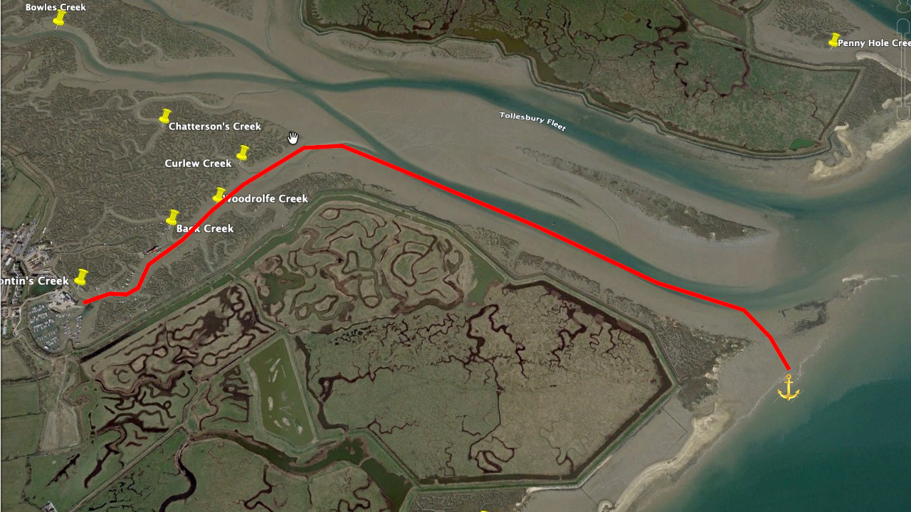
This is a screen capture of Google Earth showing the area in question. Tollesbury is on the left of the image. Naiad will be launched just where you can see the words 'ontin's Creek' (the 'B' is off screen). This is a low water shot and Woodrolfe Creek is just mud at this point. But at high water, Naiad will sail along the creek to the end, turn right, sail down the southern arm of Tollesbury Fleet, cut across the mud bank at Shinglehead Point and anchor where the I placed the anchor symbol....more or less.. following the red line.
If the wind is still strong I may see if there is a vacant buoy in the South Channel until the flood during the night has moderated, as per the forecast, and then sail out over the mud bank and anchor. I'll make that determination once I'm sailing.
Still, I'll spend the night on board, a lovely thought, and wait for the low tide on the Thursday morning. Then up anchor and sail up the Blackwater to Goldhanger.
That's plan B.
Plan C is to wait until another weather window.
Time for a cup of tea.